Original WWII German Wehrmacht Atlantic Wall defense set concerning ‘Stützpunkt Longueville-sur-Scie’ in France in 1943
0 €
Original German Wehrmacht Atlantic Wall defense set concerning “Stützpunkt Longueville-sur-Scie” dating from 1943.
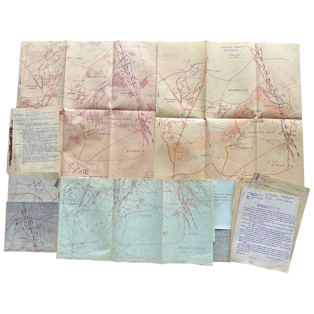
This exceptionally rare and highly detailed set consists of original tactical maps, operational reports, terrain reconnaissance studies and doctrinal documents used by German Festungspionier units during the Second World War.
The collection relates to the defense of the Longueville-sur-Scie strongpoint in France and provides a detailed insight into German Atlantic Wall coastal defense organization.
The documents and maps mention several locations including Longueville-sur-Scie, Vaudreville, Dangstanville, Lintot-les-Bois, Crosville-sur-Scie, Omonville, Belmesnil, Criquetot, St. Crespin and Crasnville.
The set includes several large hand-annotated tactical maps showing resistance nests, HKL lines, MG positions, PAK positions, communication lines, minefields, forward defensive positions and anti-tank obstacles.
The maps contain various tactical annotations, military abbreviations, defensive sectors and terrain observations used directly for operational planning and military training.
In addition, the collection contains original typed Wehrmacht documents from Festungs-Pionierstab 21 and Fest.Bau.Btl. 21 with extensive instructions concerning winter training, terrain reconnaissance, defensive construction and combat preparation.
Several German military units are also referenced including Radfahrer-Abteilung, Panzerjäger-Abteilung, M.G.K., heavy MG positions, heavy infantry weapons and battalion reserve formations connected to the defense of the strongpoint.
The documents additionally mention military personnel and officers such as Major Hoenig, technischer Inspektor Becker, Oberstleutnant Bornemann and Dauber.
The documents are dated March and April 1943 and retain original military stamps, signatures and internal reference numbers.
Particularly interesting is the combination of doctrinal paperwork together with the corresponding operational maps, creating a remarkably complete overview of practical German Atlantic Wall defensive organization in occupied France.
A historically important and visually impressive set for collectors of German militaria, military cartography, Atlantic Wall documentation and World War Two collectibles.
Map dimensions:
66 x 55 cm.
58 x 52.5 cm.
57 x 47.5 cm.
57 x 47.5 cm.
55 x 54 cm.
Article number: 19488
Originele Duitse Wehrmacht-verdedigingsset uit de Tweede Wereldoorlog, afkomstig van de Atlantikwall, met betrekking tot ‘Stützpunkt Longueville-sur-Scie’ in Frankrijk in 1943
Originele Duitse Wehrmacht Atlantikwall verdedigingsset betreffende “Stützpunkt Longueville-sur-Scie” uit 1943.
Deze uitzonderlijk zeldzame en inhoudelijk zeer uitgebreide set bestaat uit originele tactische kaarten, operationele rapporten, terreinverkenningen en doctrinaire documenten afkomstig van Duitse Festungspionier eenheden tijdens de Tweede Wereldoorlog.
De verzameling heeft betrekking op de verdediging van het steunpunt Longueville-sur-Scie in Frankrijk en geeft een gedetailleerd inzicht in de Duitse kustverdediging binnen de Atlantikwall.
Binnen de documenten en kaarten worden meerdere locaties genoemd waaronder Longueville-sur-Scie, Vaudreville, Dangstanville, Lintot-les-Bois, Crosville-sur-Scie, Omonville, Belmesnil, Criquetot, St. Crespin en Crasnville.
De set omvat meerdere grote handmatig ingetekende kaarten waarop weerstandsnesten, HKL-lijnen, MG-opstellingen, PAK-posities, verbindingslijnen, mijnenvelden, voorgeschoven stellingen en anti-tankhindernissen nauwkeurig zijn aangegeven.
Op de kaarten zijn verschillende tactische aantekeningen, militaire afkortingen, verdedigingszones en terreinanalyses zichtbaar die rechtstreeks gebruikt werden voor operationele planning en opleiding.
Daarnaast bevat de set originele getypte Wehrmacht-documenten van Festungs-Pionierstab 21 en Fest.Bau.Btl. 21 met uitgebreide instructies betreffende winteropleiding, terreinverkenning, verdedigingsopbouw en gevechtsvoorbereiding.
Ook worden verschillende Duitse militaire eenheden genoemd waaronder Radfahrer-Abteilung, Panzerjäger-Abteilung, M.G.K., schwere MG-posities, zware infanteriewapens en bataljonsreserves binnen de verdediging van het steunpunt.
De documenten verwijzen eveneens naar officieren en militaire verantwoordelijken zoals Major Hoenig, technischer Inspektor Becker, Oberstleutnant Bornemann en Dauber.
De documenten zijn gedateerd maart en april 1943 en voorzien van originele militaire stempels, handtekeningen en interne referentienummers.
Bijzonder is de combinatie van doctrinaire documenten met de bijhorende operationele kaarten, waardoor deze set een zeer compleet beeld geeft van de praktische organisatie van Duitse Atlantikwall-verdediging in bezet Frankrijk.
Een inhoudelijk sterke en visueel indrukwekkende historische set voor verzamelaars van Duitse militaria, militaire cartografie, Atlantikwall-documentatie en Tweede Wereldoorlog archiefstukken.
Afmetingen kaarten:
66 x 55 cm.
58 x 52,5 cm.
57 x 47,5 cm.
57 x 47,5 cm.
55 x 54 cm.
Artikelnummer: 19488
Out of stock